Correction: The tentative map is a subdivision map (not a parcel map) for the parcels which would each be the site for 11 homes.
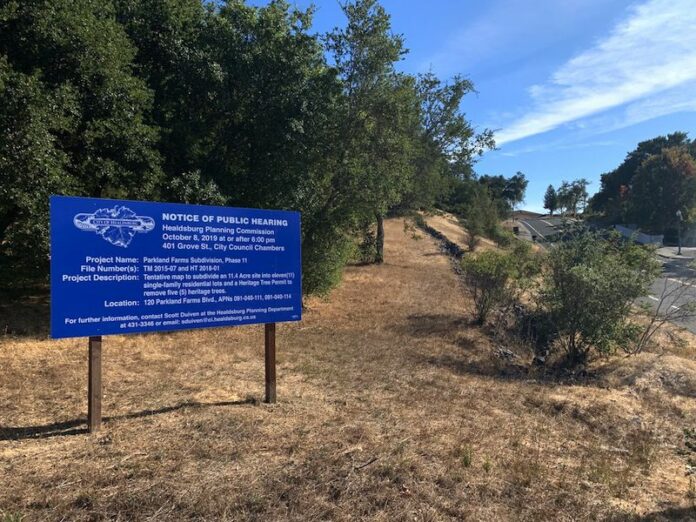
A new Parkland Farms subdivision is one step closer to reality after the Healdsburg Planning Commission gave the OK for the project’s tentative subdivision map for the parcels and associated tree removal work to remove five heritage trees on the 11.4-acre site.
The commission voted 5-0 at its Tuesday, Oct. 8 meeting approving the preliminary map. Commissioners Richard Tracy and Kevin Deas were absent.
The plan, according to the map, would divide the site at 120 Parkland Farms into 11 single-family lots with a shared access driveway.
Since the proposed site has several constraints, such as being in a riparian woodland area, and contains a faultline, historic rock wall, heavy vegetation, steep slopes and a preserved serpentine chaparral area (a plant community that contains the metamorphic state rock serpentine), a vegetation management plan was created to address these and other concerns such as fire fuel management. The developers, Urban Green Investments, also worked with private sector and city arborists to study the area and determine which trees can be preserved.
“The challenge with this project has been trying to create a subdivision that addresses the existing conditions and constraints that are on that site,” said Scott Duiven, the city’s senior planner.
There are 936 trees on the site, 20 of which meet the heritage tree status, 15 that are going to be preserved and five that are slated for removal either due to tree health or construction reasons.
For this specific site there is a 3 to 1 tree planting to removal ratio for trees of a certain height, but because the area already has dense vegetation, that 3 to 1 ratio could be too much.
“So what this project sought to do instead of the 3 to 1 mitigation in concert with an arborist, both the city’s arborist and the applicant’s arborist and fire marshal, was to develop a vegetation management and enhancement plan with the goal of addressing the dense vegetation and improving wildlife safety on the site,” Duiven explained. “The goal is to reduce the rapid transmission of flame from wildfire to the structures through selective thinning of native vegetation, generate defensible space through separation and reduction of horizontal and vertical continuity of fire fuel and through low-volume, fire resistant and well-irrigated landscape to eliminate advancement of a fire.”
Fire access roads would be 16 feet wide and would have turnouts and fire hydrants. Commissioner Fire Marshal Linda Collister said those were acceptable parameters.
James Jensen, the civil engineer for the project, said the layout and road is based on an old dirt road that winds its way to the area.
He called it, “A good basis to start from.” Grading the dirt road into a modern road would be easier than building a new road in untouched areas of the site, Jenson noted.
Barrett Elmer, with Urban Green Investments, the developer behind the subdivision, said of the project, “We think this project offers a lot of benefits to the community the first and foremost being increased housing.”
“We’re seeking tentative map approval for 11 homes not to make light of it all, it has been a long road getting here, but I think it bears repeating that each of these homes will be subject to design review and also subject to the growth management ordinance so this is a first step, albeit a pivotal one,” Elmer said.
The developers have been working on this particular project for five years.
“We studied it extensively. We hired an arborist and so did the city and together they worked on a vegetation management plan,” Elmer said.
The group has also worked to garner feedback from neighbors as far back as 2015. In April, the developers did a formal outreach by mailing out information and in September they did another outreach activity, a drop-in style meeting at the Healdsburg Community Center.
“I think we’ve tried to incorporate their comments as much as we can,” Elmer said.
In terms of the inclusionary housing aspect of the project, developers have proposed to construct seven deed-restricted accessory dwelling units (ADUs) on seven of the 11 lots.
The remaining four lots would pay the in-lieu fee for the inclusionary housing ordinance.
However, this strategy of fulfilling the inclusionary housing ordinance was a sticking point for commissioners.
Planning Commission Chair Phil Luks expressed concern about fire danger and placing these homes and their proposed ADUs in a woodland where there is a large fire fuel load.
“If this were on level land, I would applaud this proposal … it gives the city potential for more affordable housing … Still, the way the project is structured, basically seven more residences are mandated than what the zoning provides in a high fire danger area so I have a real problem in recommending to the city council that they follow this requirement,” Luks said. “What I’d like to see is if you’d have some other way of complying with the inclusionary housing rules.”
The majority of commissioners felt the same and despite passing the tentative map, urged the developer and the city to come up with a different method for complying with the inclusionary housing mandate for the project.
Other than the issues with the ADUs and a concern about taking away from the area’s visual character with the trees, commissioners said that the overall plan for the site looked good.
Commissioner Howard Brunner said that the engineer created a good design and planning, noting the first six lots are all ample in size even though they are clustered together.
During public comment two neighbors spoke and shared similar concerns regarding fire danger and lot configuration.


