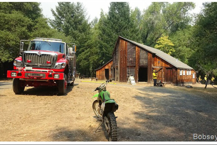
Fire crews battling the Walbridge Fire were able to save the Pond Farm pottery barn in Armstrong Redwoods State park which is a registered National Historical Place. Photo by Bob Noble
Updated Tuesday, Aug. 25, 12:35 p.m. —
The following evacuation orders and warnings have been lifted:
Map Grid 1D1 all orders lifted
East of the Sonoma Coast
North of the Russian River
West of Myers Grade Road
South of Fort Ross Road
Map Grid 1D2 all orders lifted
East of Myers Grade Road
North of Russian River
West of Cazadero Highway
South of Fort Ross Road
Map Grid 1D3 all orders lifted
East of the Cazadero Highway
North of Russian River
West and South of Old Cazadero Road
Map Grid 1C1 all orders lifted
East of the Sonoma Coast
North of Fort Ross Road
West of the south fork of Gualala River
South Stewarts Point Skaggs Springs Road
Map Grid 1C2 all orders lifted
East of the south fork of the Gualala River
North of Fort Ross Road
West and South of King Ridge Road
Map Grid 1E1 all orders lifted
All areas south and west of Willow Creek Rd.
North of Coleman Valley Rd. and Wright Hill Rd.
East of the California Coastal National Monument (BLM property)
Map Grid 1E3 all orders lifted
All areas south of the Russian River
West of Bohemian Hwy.
North and East of Coleman Valley Rd. and Willow Creek Rd.
Map Grid 1F1 all orders lifted
All areas east of Bohemian Hwy.
North of Graton Rd. and Harrison Grade Rd.
West of Harrison Grade Rd., Green Valley Rd., and Hwy. 116
South of the Russian River
Map Grid 1F2 all orders lifted
All areas south of the Russian River
East and North of Hwy. 116 (Pocket Canyon)
West of Martinelli Rd.
Map Grid 2C4 all orders lifted
South and West of Asti Road
East of Hwy 101
North of Hwy 128
Map Grid 2F1 all orders lifted
North of Canyon Road
West of Dutcher Creek Rd and the Dry Creek the actual creek
West of Hwy 101
Map Grid 2F2 all orders lifted
South of Canyon Road
East of the Dry Creek (the actual creek)
North of Lytton Springs Road
West of Geyserville Avenue
Map Grid 2F3 all orders lifted
South of Lytton Springs Road
East of the Dry Creek (the actual creek)
North of Westside Road
West of the Healdsburg city limits.
Map Grid 2G1 all orders lifted
East of Hwy 101
South and West of Hwy 128
North of Alexander Valley Road
Map Grid 2K1 all orders lifted
All areas North and East of Westside Rd.
South of Hwy. 101
West of the Russian River
Map Grid 2K2 all orders lifted
All areas west of Hwy. 101
East of the Russian River to the Windsor Town limits
North of where Windsor River Rd. dead ends, extending west to the Russian River.
Map Grid WI-A (Town of Windsor) all orders lifted
North of Windsor River Road to the northern town limit
West of Hwy 101 to the western town limit
Map Grid 4A1 all orders lifted
All areas East of the Russian River
North of River Rd.
West of Trenton Healdsburg Rd. and Eastside Rd.
South of the area between the western dead end of Windsor River Rd. and the Russian River
Map Grid 4A2 all orders lifted
East of Trenton Healdsburg Road
North of Mark West Station Road
West of the Windsor City Limits and Windsor Road
South of Windsor River Road
Map Grid 4A3 all orders lifted
East of Trenton Healdsburg Road
North of River Road
West of Slusser Road
South of Mark West Station Road
Map Grid 4B1 all orders lifted
All areas south of River Rd. from Martinelli Rd. to the intersection of River Rd at Trenton Rd.
West of Covey Rd.
North of Front St. / Hwy. 116
East of Martinelli Rd.
Map Grid 4C1 all orders lifted
North of Guerneville Road
East of Covey Road and Hwy 116
West of Laguna Rd
South of River Road
Map Grid 4D1 all orders lifted
South of Pocket Canyon/Hwy 116
East and North of Green Valley Road
West of Atascadero Creek
Map Grid 4D2 all orders lifted
South and West of Hwy 116
East of Atascadero Creek
North of Green Valley Road
NOTE: River Road and Hwy 116 will remain closed from the Hacienda Bridge to Old Cazadero Road. Hwy 116 will also be closed at Drake Road coming into Guerneville. People going to the Monte Rio, Camp Meeker, Jenner and the Cazadero areas are encouraged to use alternate routes to return home.
Updated Tuesday, Aug. 25, 8:15 a.m. —
According to the latest CalFire update, the Walbridge Fire held overnight at 54,503 acres and is now 17% contained.
The Meyers Fire is 2,360 acres and is 97% contained.
Updated Monday, Aug. 24, 7:30 p.m. —
In its evening update, CalFire reported that the Walbridge Fire is now 54, 503 acres and 7% contained.
The Meyers Fire is 2,360 acres and 96% contained.
Fire conditions will dictate when residents can return
Repopulation of the lower Russian River communities may not occur for another two to five days depending on fire conditions according to CalFire Division Chief Ben Nichols. In a 4 p.m. update Monday afternoon, Nichols said it would be “unlikely” to see the repopulation of all lower Russian River areas by tomorrow due to the current level of fire activity in the area and at the top, back valley of Armstrong Woods.
“It is overzealous at this point to expect that maybe in the next day or so. My guess would be several days at this point depending on fire conditions over the next several days. Fire is going to dictate when we get people back in the communities,” Nichols said.
He said there has been some infrastructure damage along Sweetwater Springs and it needs to be safe before folks can come back into the area.
CalFire Incident Commander Sean Kavanaugh said while lines are looking pretty good for the Walbridge Fire, 5% contained at 54,068 acres, and the Meyers Fire, 95% contained at 2,360 acres, there are still areas with active burns.
“We are having active burning over here in the east zone as we speak right now, so are we liking what we’re seeing and the work that’s being done over on the Walbridge Fire? Absolutely… but I want to make sure we’re clear that this is a very large fire,” Kavanaugh said.
In terms of how the fire is holding near Armstrong Woods, Nichols said the fire has made it down the slopes into the upper portion of the park.
“We have fire that has made it back down the slopes into the upper portion of the park near the Colonel Armstrong tree. The strike team that we have prepositioned in the park to do structure defense has mitigated the structure defense problem and they are deploying as we speak to ensure that the fire doesn’t get to the Colonel Armstrong tree tonight,” Nichols said.
He said it is critical that they keep it in the canyon proper because the slope on the west side of the park up to the fire trail is steep and if it got onto that slope it could threaten their control line.
Added moisture in the air has helped crews keep a lid on containment lines and they’ll continue to work on buttoning up areas with bulldozers and other resources according to Nichols.
The Sonoma County Emergency Operations Center Director, Chris Godley, said in the coming days the county will have more information about setting up local assistance centers.
Sonoma County Supervisors Lynda Hopkins and James Gore recognized that folks may be anxious to get back to their homes, but some areas, such as Mill Creek, have sustained heavy infrastructure damage and power lines and trees need to be cleared before residents can start returning to their homes.
“We know everybody wants to get back in but if you drive down Mill Creek Road, if you drive up Chemise Road onto Big Ridge if you drive up certain sections of Sweetwater Springs, there are some areas back there that are pretty hairy and very dangerous,” said District 4 Supervisor James Gore. “There are a lot of trees still falling, a lot of arborists and Sonoma County Public Works crews and PG&E doing significant infrastructure work to prepare us for a long road to recovery… It still looks like a war zone out there and some areas and that is why it is difficult to get people back in.”
Gore said one of the first things that happens in fire recovery is a household hazardous waste sweep where experts identify down structures and scrub the area of any chemicals, waste or leaking propane tanks.
Gore said once the county mobilizes local assistance centers they’ll set up community meetings, most likely in a virtual format, and rally state and local partners to get needed resources for recovery.


