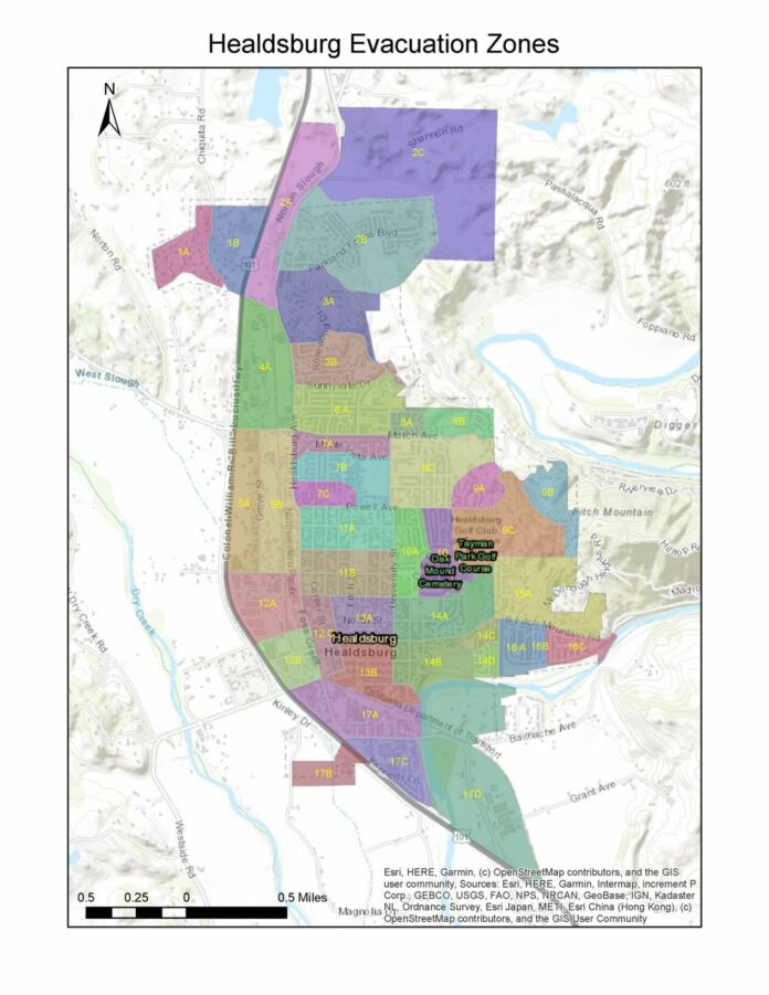
The city of Healdsburg recently released its own citywide evacuation zone map, a tool that will streamline the evacuation process and make it easier for first responders to relay information to residents in the event of an evacuation.
“The idea of the evacuation zones really started coming up after the Kincade Fire and you saw a lot of agencies push out drafts of them last year through the Walbridge and the LNU fires. The idea is that as we have fires or other disasters, having predefined zones helps the public know if they are being evacuated or not,” said Healdsburg Police Lt. Matt Jenkins.
The zones were created with the idea in mind of where the most impacts would be from natural disasters like fires and floods.
“In doing the evacuation zones we looked at a couple of things, one, the geographical layout of town whether it’s streets, rivers, ridgelines, other natural breaks and also where the impacts are likely to be. So (it’s) looking at where fires could come in, but also trying to make the zones universal so we can use them for floods and other disasters that may happen,” Jenkins said.
He said what they didn’t want to do was to have a set of evacuation zones for fires and a separate set for flooding, earthquakes or whatever the disaster may be.
Additionally, according to a statement from the city’s Facebook page, “In working with Sonoma Sheriff, we decided that this approach to smaller zones will serve us better in the long run because it:
● Allows for greater flexibility when evacuating community members.
● Allows for zones to be more universal so they work just as well for floods, for example, as they do for wildfires.
● Allows for a more orderly re-population so it’s easier and less confusing when people return after a disaster.
● Allows our police department to be more strategic when it comes to operations.”
Navigating the Healdsburg map
The city is currently working on releasing a higher-resolution map that’s easier to read, as well as an address look-up tool.
“The map we have pushed out now is really hard to see for someone unless they can look at the map and really find their house. Our GIS specialist and our IT department is working on an address lookup tool and it looks like that will probably be available to the public mid to late next week. Someone will be able to go in, enter in their address and it will tell them exactly which zone they fall in,” Jenkins said. “The general idea is the lower the number is on the north end of town, the higher the number, the south end of town. It progresses through that.”
He said once the look-up tool is available it will be important for residents to look up their address so they know what zone they are in.
“Regardless of the type of evacuation that could be occurring once they (residents) know what zone they’re in, it shouldn’t be changing,” Jenkins noted.
In the event of an emergency, evacuation orders for specific zones will be sent out via Nixle, SoCo Alerts and/or the wireless emergency alert system.
Unincorporated areas of Healdsburg, like Dry Creek Valley and Fitch Mountain, will utilize the county’s evacuation zone map.
“The county has been working extensively with their (map). It was pushed out heavily during Walbridge and they’ve been working on some refinements and we’ve been working with them and how they interface with the city and our zones as well,” Jenkins said.
The county released their official evacuation zone map for unincorporated areas in Sonoma County as well as most of the incorporated communities on May 21. They are standardized evacuation zones for Sonoma County.
In the past, evacuation zones were different for each incident, now the zones will remain the same.
Jenkins said the county department of emergency management is going to be pushing out a campaign about knowing your zone and zone number.
“With wildfire season upon us, these official evacuation zone maps are an essential part of doing everything we can to make sure our families and neighbors are safe if disaster strikes,” Supervisor Lynda Hopkins, chair of the Sonoma County Board of Supervisors, said in a statement. “We all need to learn our zones and know what to do and where to go if our zone is ordered to evacuate.”
To find your zone, go to: socoemergency.org/evacuation-map/ .
The website also has an address look-up tool that allows you to find your zone number and shows you if your zone is under an evacuation order.
The county also recently launched an evacuation tag program for unincorporated community residents. The tag is meant to notify first responders that a property or home has been evacuated in the event of a mandatory evacuation order.
When asked if the city of Healdsburg would consider an evacuation tag program, Jenkins said they don’t have plans for one.
“It’s something we have been evaluating and I had some conversations with other law enforcement agencies throughout the county and right now the sheriff’s department is the only agency that’s committed to using those tags and a lot of it has to do with the different geographical areas that they serve. The sheriff’s department is serving a large rural area with a lot of large parcels and a lot of dirt road driveways leading up to residences, so having a tag at the end of those driveways really serves them well for going through and doing evacuations. It’s much different in the incorporated area. For example, having 100 tags on Piper Street isn’t as helpful to us necessarily and the other problem that we encounter with the tags, is we have two sets of evacuations, an evacuation warning to be prepared to go and then the mandatory evacuation,” Jenkins said. “If people leave during an evacuation warning and they put their tag out, anyone is still able to drive up and down the streets and it becomes an advertisement for people who are looking to break into homes and that the house is vacant.”
If a mandatory evacuation were to take place, the Healdsburg Police Department would conduct door-to-door notifications to make sure people know of any mandatory evacuation orders.
“We’re committed that if we have mandatory evacuations we’re still going to be doing door-to-door notifications making sure that people know that there’s an evacuation going on. Long story short, we’re still evaluating whether we’re going to do those tags but right now we have not decided to implement them.”
Streamlining the evacuation order process for first responders
“With respect to fire or other evacuations obviously what we can do as first responders is we can look to that map and identify an area that needs to be evacuated whether it’s a section or a subsection and we can relay that information to dispatch and it will alert just those specific neighborhoods that need to be evacuated,” said Healdsburg Fire Chief Jason Boaz. “It creates an environment where we don’t have to call dispatch and start giving them streets as parameters, like north of Powell Avenue or south of University. This way we can just identify certain sections of the city that may be threatened and evacuate them in a more orderly fashion.”
He said it serves as a good tool to identify specific areas for evacuation.
“I think you saw this a lot with Kincade when the evacuation notices went out, trying to describe the area you want evacuated and the idea with predefined zones is we can pre-describe what that zone is. It’s basically a copy and paste so you’re not trying to do it on the hood of a car in the dark on Saturday at 2 a.m. when a fire is quickly approaching.”
With the predefined zones, it’s already a defined zone and you can simply say “evacuate zone 1A,” for instance.
“People should be able to readily understand (their zone) with less confusion,” Jenkins said.
City of Healdsburg spokesperson Rhea Borja said the city evacuation zone map is available on the city website and once the high resolution map and address look up is available they’ll notify residents on all of the city social media channels and post the information to the city website.
“We do have it online, but we will provide a higher res version and once the address lookup tool is ready we will be promoting that as well,” Borja said.


