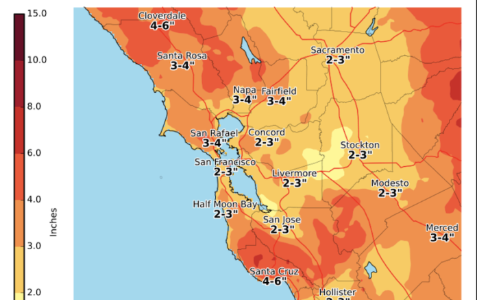
Sonoma County and its corresponding public safety partners are preparing for the incoming atmospheric river that has prompted a flash flood warning for the county and for the burn scars of the Walbridge, Meyers, Glass and Kincade fires, areas which face the greatest threat of debris or landslides. The warning will be in effect through Thursday afternoon.
According to the Sonoma County Sheriff’s Office, as of Jan. 26 there are no evacuation orders in effect.
The storm will bring a relatively narrow cold front and the heaviest rains will be felt late this evening from about 9 p.m. to 2 a.m.
“We expect the rains that have started will begin to peak at about 9 p.m. this evening (Tuesday) and they’ll continue with fairly heavy intensity to about 1 or 2 a.m. this morning,” said Chris Godley, the county’s director of emergency management.
The storm is also expected to bring significant winds up to 60 mph near the coastline and into the higher elevations.
“We can expect with the traditional issues of high rainfall we could see problems posed by trees coming down across roadways or bringing down wires,” Godley said.
Godley said the burn scars for the most recent fires could present a challenge.
“This is a significant amount of rainfall that should occur at a fairly short period of time and that is why the National Weather Service is expected to exceed what we call the threshold for debris flows within the burn scars. That is based on the geology, type of vegetation, the damage done by the fire, the steepness of a slopes, its orientation to the sun, all of those factors come into play in terms of how much rainfall can safely fall before it begins to erode and start causing the soils to move,” Godley said.
In this case with the Walbridge, Meyers and Kincade fire areas about four tenths of an inch per 15 minutes, or one inch in one hour, are the thresholds at which the county might expect to begin to see potential debris flows or landslides in those particular areas.
“(There is) not a guarantee that that is going to occur but that does indicate a possibility that that might be the issue here … But I should also note that our forecast relative to the other counties is relatively good,” Godley said. “We’re relatively hopeful here in Sonoma County that we’ll move through this.”
A debris flow is when the water starts flowing down a slope and creates a kind of a slurry of debris and rocks, whereas a mudslide is when a piece of land mass actually slips and slides down a slope.
Godley said the county’s Emergency Operations Center has not been activated, but the Sonoma County Fire District has prepositioned a strike team of five engines in Santa Rosa in the event that additional first responders are needed.
“Right now, we have normal staffing. All of our staff are aware of the storm coming in and the hazards that it could present. Deputies will be available in the community to help community members if and when they’re needed if anything does happen,” said Misti Wood, the Sonoma County Sheriff’s Office Community Liaison and Communications Officer.
Wood advised folks to be aware of their surroundings and to be alert. It’s also good to remember to never drive through a flooded roadway, “don’t drown turn around,” as the saying goes.
Folks should sign up for Nixle and or SoCo Alert in order to stay up to date on all of the latest emergency notifications. You can also call 2-1-1 or visitsocoemergency.org if you have any questions.


