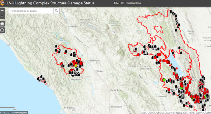
While damage assessment is still ongoing for the Walbridge and Meyers fires, and the LNU Lightening Complex as a whole, CalFire has released a map of properties damaged and destroyed that includes an interactive feature where residents can input their address to see if their home has been destroyed or damaged, or if it is still intact with no sustained damage.
The map includes a list of damaged and destroyed structures provided by CalFire damage inspection teams. According to the county of Sonoma, damage inspections and locations are preliminary and numerous sites still require confirmation.
Folks can navigate the map by zooming in to a certain location or by searching for an address in the search bar. Red icons label properties that have been destroyed, orange icons indicate major damage, yellow indicates minor damage, green signals that a home was affected, and black icons identify properties that have no damage.
If you enter an address and the structure isn’t identified by one of the icons it means the property has not yet been assessed.
To view the map, click here: tinyurl.com/y678sucl.
CalFire Incident Commander Chief Sean Kavanaugh said assessment teams are about 65% complete with damage assessment on the east zone (Sonoma County area) of the LNU Lightening Complex.
During a community meeting on Aug. 26, county Director of Emergency Services Chris Godley said that 91 structures had been identified as enduring major damage or destroyed.
“Within the fire zone just on the east zone, there’ve been 2,507 residences within the fire zone itself that were not damaged, I think that’s positive,” Kavanaugh said at a Friday morning CalFire press conference. “Over on the west zone, we’re about 55% complete on the assessment and there’ve been 253 homes within the fire perimeter that are not damaged as well.”
He said the assessment process is ongoing and that numbers will get updated about every couple of hours as the team enters in data.
“We want to make sure that it’s validated and that we get it out to everybody,” Kavanaugh said.
With that said, he noted that there’s still a lot of work to be done to button up the lines of the Walbridge Fire, yet crews are still making strides in progress every day.
“We haven’t had a lot of fire growth in the last 24 hours, which is good for us and good for the troops out on the ground as we continue to put lines in and around the fire and the entire complex,” he said.
As of Friday afternoon, Aug. 28, the Walbridge Fire is 25% contained at 55,353 acres. While several mandatory evacuation zones have been downgraded to an evacuation warning there are still areas, such as Armstrong Woods Road north of Rio Nido Road, near active fire that are still under a mandatory evacuation order.
“It’s important to remember that as we begin to shrink some of these evacuation zones and allow people back in for repopulation that the remaining zones that are still under evacuation are zones that are actually much closer to the fire and much closer to the actual operations of fire personnel,” Sonoma County Sheriff Chief Mark Essick said during the morning press conference.
In a video update District 4 Supervisor James Gore said because the fire is still burning, what crews are doing is going around and making dozer lines and doing air drops all around the perimeter of the fire to make sure that the edges of the fire get fully contained.
As CalFire crews continue with damage assessment and as utility crews continue with getting infrastructure back up and running, Kavanaugh asked that folks continue to remain patient teams continue to work on the fire.
“We ask that people be patient, we’re doing that as quick as we can and it’s a priority for us to get people in their homes as quickly as possible,” Kavanaugh said.
76.8
F
Healdsburg
April 21, 2025


